

GRIB Explorer Plus app for iPhone and iPad
Developer: OCENS, Inc.
First release : 24 Apr 2014
App size: 76.54 Mb
GRIB Explorer Plus (GE Plus) works with any GRIB that is formatted in a manner consistent with WMO GRIB1 standards, including those acquired via email or web sources.
However, to take full advantage of GE Plus a subscription to the OCENS Everon data service is highly recommended. Working together with Everon, GE Plus is able to rapidly deliver GRIBs for any location, to any location on earth via satellite or wifi connections. There is a low subscription fee to use Everon, either through Pay-as-You-Use or Unlimited Plans (www.ocens.com/ige).
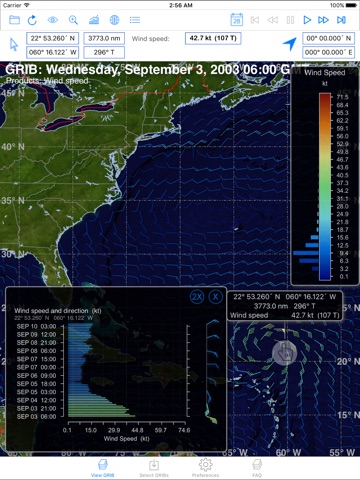
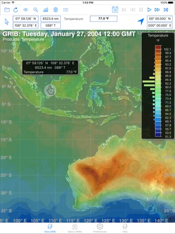
GE Plus melds GRIB weather & ocean data into sensational images carrying unparalleled insights into the environment around you. GRIB data is overlaid on high resolution earth imagery for any location in the world. Fingertip response reveals high accuracy lat/lon position, bearing and range from your Home Location to the point under study &, of course, the weather or ocean parameter value(s) at the subject point.
GE Plus also adds Satellite Mode to conventional Wi-Fi IP retrieval. Satellite Mode enables connectivity from Plus through Iridium, Inmarsat and Globalstar satellite phones & the OCENS Everon data services. Obtain the highest quality weather & ocean data FOR anywhere on Earth FROM anywhere on Earth!
One-of-a-Kind Tools
GE Plus’s Trip Planner displays the weather along a route through time. Draw a desired trip on the GE Plus GRIB & use Trip Planner to search for the best combination of weather conditions for your trip or to adjust departure dates or the whole route entirely because of unacceptable forecast weather or ocean conditions that are revealed only with the very special tool.
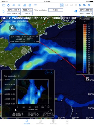
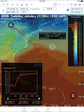
Route Finder narrows your analysis to a single frame of data. Draw a route or transect across any portion of the GRIB frame in front of you. Route Finder responds by casting a 2D chart to show the changes in parameter value(s) along that line. Use it to changes which are stunningly obvious in Route Finder’s 2D graph that are less so across the whole field of the GRIB frame. Move your finger into the graph. The Route Finder chart displays the actual values of each parameter in the graph at that point AND relates them to their position on the transect by plotting a pointer on that transect.
Time Profile tips the Route Finder on end and pulls insights from your GRIB data that are generally not easy to see without a great deal of effort and documentation. Instead of staring at a particular spot as you page through each frame of your GRIB, simply launch Time Profile and point to that spot on the current frame. Time Profile displays a chart of weather or ocean conditions at that point through all frames of the GRIB. Acquire a multi-frame, multi-day GRIB, drop your finger pointer on a location and see a graph of precipitation totals at that point for each frame. Or identify wind shifts. Move your pointer around the screen & the Time Profile graph dynamically adjusts itself to your target & its underlying weather variables.
Disclaimer: 1. Continued use of GPS running in the background can dramatically decrease battery life.